Day Two - August 15, 2001
Big Sur to Guernville on the Russian River
 Got
up early - had a great sleep, broke camp, packed up the bike and headed out.
I stopped in Big Sur Village
at a place called Big Sur Bakery for some coffee with a fried egg, onions &
tomato bagel sandwich. Excellent. I sat for a while on the sunny patio looking
over the beautiful green valley. It's been probably 15 years since I've been
through Big Sur. Last year I went straight up to Laguna
Seca Raceway via Highway 5. Not exactly the same scenery as I'm enjoying
now. I'd love to come back here and spend some time, but not this time. I paid
the bill and got on the bike for the day's ride.
Got
up early - had a great sleep, broke camp, packed up the bike and headed out.
I stopped in Big Sur Village
at a place called Big Sur Bakery for some coffee with a fried egg, onions &
tomato bagel sandwich. Excellent. I sat for a while on the sunny patio looking
over the beautiful green valley. It's been probably 15 years since I've been
through Big Sur. Last year I went straight up to Laguna
Seca Raceway via Highway 5. Not exactly the same scenery as I'm enjoying
now. I'd love to come back here and spend some time, but not this time. I paid
the bill and got on the bike for the day's ride.
Riding out of Big Sur first thing in the morning is amazing.
The coastal clouds were pouring over the mountain to my west like vapor.
It was a bright sunny morning, for a while. As I traveled North through
"Andrew
Molera State Park" (which is just South of Carmel Highlands and
not pictured on the map) It got cold. Cold and wet. Heavy drizzle greeted
me as I traveled through The Carmel Highlands, Monterey, Castroville
& Santa
Cruz.
As I approached Point
Año Nuevo, I passed a fellow motor cyclist on an old, I'm guessing,
early 70's BMW. He had rigged up a pair of wicker baskets as saddlebags
and was wearing only a light windbreaker over his T-shirt. As I passed him
I could see that his windbreaker was full of air. He must have been freezing
because I was wearing lots of warm stuff and I was cold.
 When
I stopped in Half
Moon Bay for gas and to make a couple of phone calls, he also pulled in
for gas. He was freezing. We talked for a while. He told me that he was headed
for Seattle, but couldn't take the cold along the coast anymore. He said that
he had a large wool sweater but wasn't wearing it because he didn't think it
would fit under his windbreaker. I suggested he tries, and maybe travel inland
where it would be much warmer instead of along the coast. He had never taken
a motorcycle on a cross-country trip before and was hungry for advice. His face
shield was old and scratched so I offered him some Plexis, a really good plastic
polish, so he could see better. We rode together for a while and I eventually
passed and lost sight of him. He caught up to me in Pacificia and said, "Thanks
for the advice. It's much easier to take the cold with my sweater on."
When
I stopped in Half
Moon Bay for gas and to make a couple of phone calls, he also pulled in
for gas. He was freezing. We talked for a while. He told me that he was headed
for Seattle, but couldn't take the cold along the coast anymore. He said that
he had a large wool sweater but wasn't wearing it because he didn't think it
would fit under his windbreaker. I suggested he tries, and maybe travel inland
where it would be much warmer instead of along the coast. He had never taken
a motorcycle on a cross-country trip before and was hungry for advice. His face
shield was old and scratched so I offered him some Plexis, a really good plastic
polish, so he could see better. We rode together for a while and I eventually
passed and lost sight of him. He caught up to me in Pacificia and said, "Thanks
for the advice. It's much easier to take the cold with my sweater on."
We stayed pretty close until we got to San
Francisco where we got separated in traffic and I eventually lost sight
of him, but I'm pretty sure that he took my advice and began his travels inland.
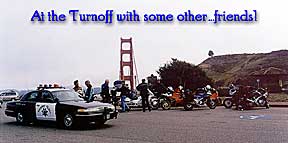 I
crossed the Golden Gate Bridge, the top of which was shrouded in fog, and pulled
over at the North viewpoint. It was a zoo. Tourists everywhere. Huge busses,
drivers blowing their horns to get their passengers back on board. I got out
of there as fast as I could.
I
crossed the Golden Gate Bridge, the top of which was shrouded in fog, and pulled
over at the North viewpoint. It was a zoo. Tourists everywhere. Huge busses,
drivers blowing their horns to get their passengers back on board. I got out
of there as fast as I could.
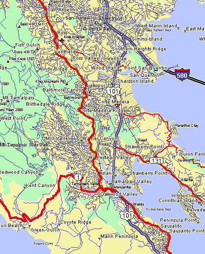
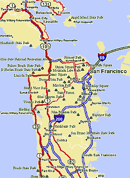
Up the 101 to Sausilito. At this point I have to make a choice.
I could continue up the coast through Stinson
Beach and Point Ryes,
or take another road that I hadn't ever considered taking that goes north, but
further inland. It was so cold that I made the decision to travel inland, at
least for now. The road, which is not identified very well on the AAA (Automobile
Association of America) maps that I was carrying very well, runs through Corté
Madera, Larkspur, Kentfield, San Anselmo & Fairfax - all just to the East of
where I was, Mill Valley.
These towns are so close together that's it's hard to know where one stops and
another begins. Lots of traffic and cops - lots of cops. I was hoping that the
route I had chosen a while back would not all be like this. It was getting to
be lunchtime so I decided to stop in San
Anselmo for lunch. After a little searching and asking locals where a good
place to eat was, I found a great little Mexican/Southwest cuisine place called
"Jane's Taco". The Fish tacos are excellent.
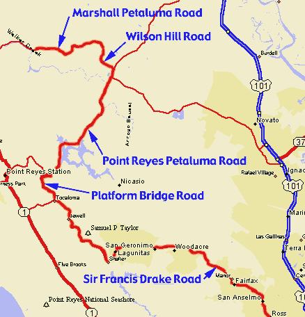
After a couple of beers and a good lunch, I was ready to
get out of these little up scale crowded towns, so out to the FJ and on
the road we go. Following a small black line on my map, I wound my way through
the countryside on Francis Drake Road. Through the Samuel P. Taylor State
Park to Platform Bridge Road, to Point Reyes Petaluma Road, to Wilson Hill
Road, to Marshall Petaluma Road to...
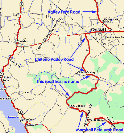
an unnamed road (I couldn't find a name for this road anywhere!), to Chileno Valley Road, to Tomales Road, to Valley Ford Road, to...
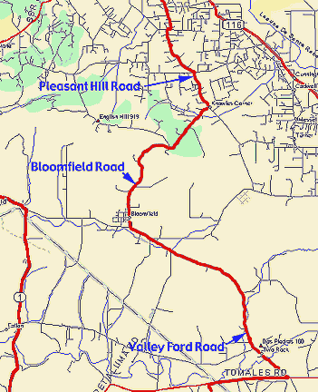
to Bloomfield Road, to Pleasant Hill Road which ultimately
got me to State Route 12 (Bodega Highway) where it intersected Highway 116
in Sebastopol. There was nothing special about that route other than it
was a challenge to navigate, and it was nice and warm. The countryside changed
from Coastal to oak savannah with some cattle grazing and small farms scattered
about. All things considered, it was quite nice. Rolling hills and well
paved roads with long sweeping corners. Lots of fun.
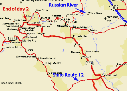 From
Sebastopol,
I took Highway 116 North to where it met the Russian
River in Guerneville. From there the highway goes west towards the coast.
It was quite warm and the river looked inviting, so I started looking for a
place to camp for the night. There were no public camping places that I could
find because, it seems, that all the land around the river is privately owned.
I was able, however, to find a private camping area. It was all right - lots
of kids running around and pretty noisy. The campsite I found was pretty small
but fairly private with lots of trees and shrubs around, a little grass to set
up my tent on and it was overlooking the river about 100 yards away. There was
a large array of flood lamps lighting up the beach beneath me that were left
on all night, so no stars tonight. I took a little walk around town to take
in some sights. A nice place Guerneville. A younger crowd - lots of bars and
restaurants. I grabbed some food and beer at the local grocery store and headed
back to camp.
From
Sebastopol,
I took Highway 116 North to where it met the Russian
River in Guerneville. From there the highway goes west towards the coast.
It was quite warm and the river looked inviting, so I started looking for a
place to camp for the night. There were no public camping places that I could
find because, it seems, that all the land around the river is privately owned.
I was able, however, to find a private camping area. It was all right - lots
of kids running around and pretty noisy. The campsite I found was pretty small
but fairly private with lots of trees and shrubs around, a little grass to set
up my tent on and it was overlooking the river about 100 yards away. There was
a large array of flood lamps lighting up the beach beneath me that were left
on all night, so no stars tonight. I took a little walk around town to take
in some sights. A nice place Guerneville. A younger crowd - lots of bars and
restaurants. I grabbed some food and beer at the local grocery store and headed
back to camp.
After a little food and beer, I took another walk and my
cell phone rang. It really surprised me because it wasn't who I was expecting.
It was a friend of mine who was near my home and wanted me to guide him
to our favorite sushi bar I had told him about. 500 miles away and I'm giving
directions to something 5 minutes drive from my home. Go figure.
I headed back to camp, a couple more beers, for medicinal purposes only,
and to bed. I planed to leave real early the next morning and head back
out to the coast. I knew it would be cold, but I figured it had to be better
that camping with all the noise, lights and people.
273 total miles traveled for day
2.